
Intro
After our adventures crossing the Antarctic Circle and at Detaille Island, we headed North with haste. The ocean was rough enough that once again, the portholes on my lower cabin were closed for the journey. After a rocky might at sea, we had a leisurely morning as we continued to our next destination, Fournier Bay.
This was our penultimate stop on the trip and we had diving planned.
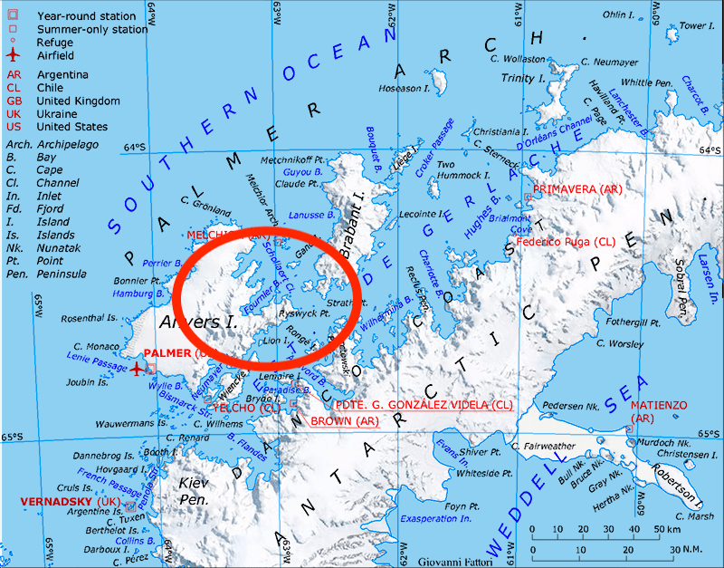
Fournier Bay
Fournier Bay was named after Vice Admiral Ernest Fourier of the French Navy. The bay itself is 8 nautical miles long and 3 nautical miles wide and is on the north coast of Anvers island. The maps below are from Wikipedia.

We arrived to beautiful conditions in this protected bay. It was literally the ONLY spot on the weather map that had anything even close to decent conditions — purple is bad!

This is another good place to stop and stress something about trips to the Antarctica — you are at the complete mercy of the weather conditions. The team at Oceanside did an excellent job of “skating to the puck” and reading the Tarot cards to find the ONE spot on pretty much the whole peninsula conducive to land expeditions, much less diving.
The scenery as we made our way to Fournier Bay was spectacular.


Pre-Diving Orcas
We arrived to Fournier Bay around 1:00pm and had amazing conditions. It really is unbelievable given the above weather map. I got my camera all ready to go and in the underwater housing with the vacuum seal set when I heard the “we have Orcas off the starboard side of the boat” call over the loudspeakers. I went outside and decided to go back to my cabin, get my camera out of the housing, change the lens to the 100-400 and take some pictures. Insanity indeed!


I was frantic getting back to my room to get the lens changed and the camera back in the underwater housing and pressurized to test it before diving with it. I got everything re-configured and then went to the back deck to load my dive gear into the RIB when I saw more Orcas right next to the guides on the RIBs. All I could do was take some video on my iPhone.
Iceberg Dive
We were finally going to get to dive on an iceberg! But, first, I had to deal with a small problem…
Before I left the Hondius, I had somebody check my drysuit zipper to ensure that it was completely closed. I made the mistake of trusting their check. When I got into the water, I immediately felt freezing cold Antarctic water get into my suit. I quickly saddled up to the boat with my right hip out of the water as they tried to finish closing my zipper. However, my weight belt and BC belt were covering the zipper closure which made things a bit tougher.
We finally got the zipper closed but not before I had quite a bit of water in the suit; however, I wasn’t about to miss my one chance to dive icebergs in Antartica!
It was a great experience.
Each iceberg is unique and this one was no exception. There is usually a change in buoyancy as the water content changes from saltwater to freshwater near the melting iceberg — but this one was extreme. It also had some swell and movement due to ocean currents. We were all doing our best to maintain buoyancy as we got pushed around by the water.
Below are some of the photos I took. You can see the cool texture, ripples, etc. in the iceberg structure.


Becky got a couple memorable shots of me on the iceberg as well:


Post Dive RIB Tour
After all the excitement, we still had more in store.
There was no landing planned on this stop so we spent some time cruising around the amazing iceberg and glacier structures. I only had my iPhone to take pictures since my primary camera was safely sealed in the underwater housing.


More Humpbacks
If you are still following along, we’ve had quite a day so far. But we had more in store.
I had my heated vest on but my body was definitely cold after having water dumped into to my drysuit, but now was NOT the time to head back to the ship.
We had humpbacks around and they didn’t care one bit that we were there. I only had my iPhone but I got some video of them. You can see just how close they are to us. Below are two quick videos:
Day’s End + Tomorrow
What a day we had in Fournier Bay.
I got back to the boat, had a hot shower to shake off the cold from my “not-so-dry drysuit dive,” and went to the main deck to get some coffee. All of sudden, I heard about a leopard seal float past on an iceberg. Could they day get any more epic? I guess this is what you would call the “Antarctic Transportation System.”


Our plan was to head to Deception Island for our last stop.


We were warned that things might not go smoothly given the forecast. Again — purple is BAD an you can see what is headed our way. The map in the middle covers the entire region with Ushuaia / Argentina near the top and the big purple cloud pushing into the Drake Passage….
References
Map 1 : By edited by Telim tor – Own work, using map File:Ant-pen map.png from Giovanni Fattori, CC BY-SA 3.0, https://commons.wikimedia.org/w/index.php?curid=5999243
Map 2 : By Gi – Own work, CC BY-SA 4.0, https://commons.wikimedia.org/w/index.php?curid=48711353
Brett-unbelievable story and pictures…wow…can’t even imagine all the “sense of adventure” …but glad it was you vs. me with the icy water in your dry suit 🙂
Thanks, Mark! It was definitely an adventure.